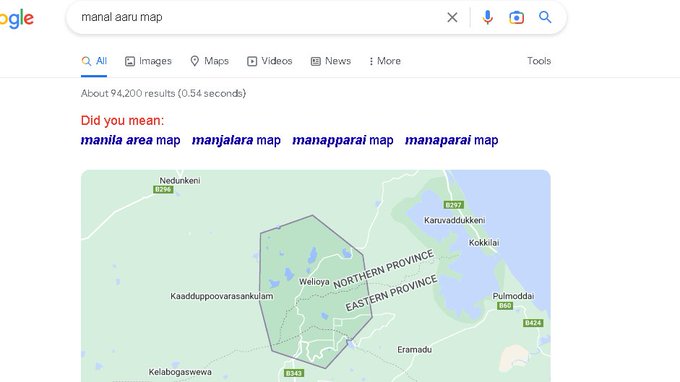
Manal Aaru/மணலாறு - another Tamil land that became a Sinhalese colony known as Weli Oya. Manal Aaru is part of Mullaithivu District & now more lands in Mullaithivu are being taken over for the LK state.

If you type Manal Aaru in google today, the name listed will be a Sinhala name. In the near future, the Tamil identity of its land will be erased completely.
Initially, the area had a total of 13,288 Tamil families (TF) living in 42 villages for generations, including:
- Kokkulai Grama Sevakar Division (1516 TF)
- Kokku –Thoduvai Grama Sevakar Division (3306 TF)
- Vavunia North Grama Sevakar Division (1342 TF)
It also included other Divisions of Mullaitivu District:
- Naiyaru and Kumulamunai ( 2011 Tamil families)
This was a traditional Tamil farming village with farms on smaller and large scales.
In 1984, Tamil families living in these 42 villages for generations were asked to vacate their homes and farmlands within 48 hours by Sri Lankan State forces. Resistance to this led to the 1984 Manal Aru massacre and the Tamil population was progressively driven out.
16 April 1988: Weli Oya was proclaimed the 26th District of Sri Lanka. Manal Aru lies north of the Sinhala colonization scheme of Padavia & was brought under the Anuradhapura administrative district.
The driving force behind the Weli Oya was Gamini Dissanayake (also the person behind the Jaffna library burning), Lalith Athulathmudali, Cyril Mathew, N.G.P. Panditaratne. They openly promoted colonization of Sinhalese in the North and East and were frontrunners in Weli Oya after driving the Tamils out by using the Sinhalese army. 3364 Sinhala families, most of them ex-convicts, brought straight from prisons, were settled in Weli Oya. Settlement of convicts affected nearby Tamil villages, crimes ranging from robbery to rape committed by convict workers were reported in large numbers.
A Tamil village known as Thannimurippu was renamed Janakapura to honor the Sinhala army, Major General Janaka Perera. "Mullaitheevu district was the worse affected district by 3 decades of war & tsunami. It suffered damage & loss of life, property & livelihoods & bore the brunt of the war during the last phase of the war." Now, they are still fighting for their land. While we fight for justice for genocide, we must equally fight for Tamil genocide while native land is being forcefully taken away and resettled with the help of the Sri Lankan army and state funding and violence.
"Painful Forgotten History of Eastern Province - Amparai District"
1st Tamil massacre took place here & the life of Tamils from Amparai has not seen much progression. To date, this area & its people have been used as chess pieces in the political arena.
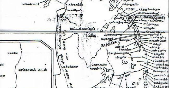
The first drop of blood for the political aspirations of Eelam Tamils was shed on this soil! The original area of Batticaloa district consisted of a large tract of land stretching from Verukaal in the north to Kumukanaru in the south. The Bay of Bengal was its eastern border and the western border was the Uva Hill Forest.


After Sri Lanka became independent, the vision of the River Valley Authority was created to increase rice production in the dryland and boost the development of the country. The land targeted by this group was the Kaliodai river in the Batticaloa district.
The Pattipalai River (or Kaliodai River), which flows from the Madulseemai area of Badulai and joins the sea at Oluville, was named Kalloya. The "Kalloyap Valley Project" was started on August 23, 1949, by then Prime Minister T.S.Senanayaka.
A large number of Sinhalese from other provinces and Tamils from other areas in Batticaloa were settled in the Pattipalai area. Then, the Pattapalai area was renamed "Kalloya". Within a few decades, the name Pattipalaya has disappeared from history!
During this time, the government wanted to create a water reservoir in Inginiyakalai. This was to be done by intersecting a river there and connecting it with ponds like Kondaivattuvan in Amparai. Although it was planned that the water flow from Andela Oya (Mandurth Thillaiyaru) to Pannala Oya (Sagamath Thalibotaru) could be regulated and irrigated through this project, later due to various political reasons its boundary was shrunk.

The reservoir was completed within a year and it was named "Senanayaka Samudram" to honor the PM. A large number of people from other districts were settled in the Kalloya area by now.
Although it was promised that the local people of Batticaloa District would be settled in Kalloya area, when it was all executed, it did not happen.

When "Kalloya Massacre" took place on June 11, 1956, 1st massacre of Tamils - killing over 150 Tamils, the few Tamils who settled ended up leaving this area.
19-03-1960: on the recommendation of the re-delineation of constituencies in 1959, a new constituency called "Thikamadullai" was created and a new town called "Amparai" came into existence.

However, in early 1961, areas in the south of Batticaloa District: Pattiripu, Kalmunai, Potthuvil, Pattiruppu, and Thikamadullai constituencies were included.

One year after the formation of Thikamadulla Constituency, Thikamadulla, and its neighboring Kalmunai, Pothuvil constituencies, and southern part of Pattiripu were proclaimed a new district called "Amparai".

In 1947, an old administrative division in Batticaloa district under the name of "Vindanaiptu" was merged with Monarakalai district. In 1976, this area, along with "Makaoya - Patiyathalawai" & "Thekiyatta Kandi" from Badulai district were merged under Amparai. This is the geography of stolen Tamil lands now we know as Amparai. Such history is not limited to this district but to many districts in Eezham. Sadly, the continuous loss of land based on ethnic and religious division continues to happen. From the first Tamil massacre to continuous Genocide (via loss of native land) happens all over Eezham, especially in the Easter province. Sad reality and fight for liberation to continue....
Source:
----------------------------------------------------------------
Stats - Amparai [1963 - 2012]:
- Sinhalese population:  from 61,996 (29.28%) to 251,018 (38.73%)
- Tamil population:
from 61,996 (29.28%) to 251,018 (38.73%)
- Tamil population:  49,185 (23.23) to 112, 750 (17.40%)
from 61,996 (29.28%) to 251,018 (38.73%)
- Tamil population: 49,185 (23.23) to 112, 750 (17.40%) 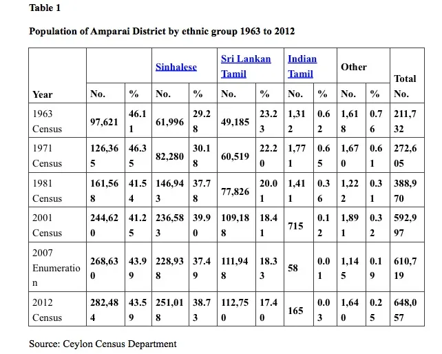
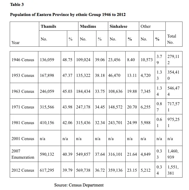
Stats of Eastern province: - Tamils: - 1946 - 48.75% - 2012 - 39.79% - Sinhalese: - 1946 - 8.40% - 2012 - 23.15% Sinhalese colonization is the main reason for this incline in the Sinhala population.
The table below shows stats of military-occupied lands in Jaffna: the total area of the Jaffna district: 1,025 Sq.Kms armed forces occupy 7,933.63 acres (32.35 Sq.Kms) of land. This stats does not include armed force-occupied lands in Kilinochchi, Mullaitivu, Vavuniya & Mannar

From the stats above, major colonization in the East has driven Tamils out as the majority ethnic group from its own homeland. LK State continues to do this in the North and many other parts of the east as well. Before we know it, Tamil land will be no more...


No comments:
Post a Comment